


Taiwan Typhoon Report
for Tuesday, October 1st all day
- Chiayi County
- Kaohsiung City
- Tainan City
- Pingtung County
- Hualien County
- Taitung County
from the EVENING of Tuesday, October 1st
- Penghu County
Taiwan Typhoons
Typhoon KRATHON
Updated: 10/1/2024
The forecast for KRATHON is for it to make landfall at Kaohsiung around Wednesday morning. Then, it will then turn northward and move along the central mountain range of Taiwan and finally east at Hualien leaving Taiwan by Thursday morning.
Expect Torrential rainfall warnings across Taiwan through Wednesday and Thursday, though the extents are not forecast to be record-breaking.
However, school closures are expected.
There is potential for storm surge damage in Kaohsiung with it being both the site of landfall and among the lowest elevations of population centers in Taiwan.
Additionally, Kaohsiung could experience extensive wind damage as the storm will be arriving at its greatest strength at Kaohsiung.
A unique feature of the storm is that it is the first typhoon in nearly a half-century to make landfall at Kaohsiung.
Another surprising feature of the storm is its abrupt northward turn. With the storm facing the whole of Taiwan Straits - seemingly a natural path for it to take - at the SAME time on Wednesday, at about 1500 meters up, there's a river of cool, northward moving air - a mid-latitude trough - that's arriving. The direction and the temperature difference will create a pressure imbalance which will pull the storm northward. The trough itself is not a permanent feature of the atmosphere - it just was one feature that developed and arrived at the same time the storm did.
Typhoon KRATHON 24-Hour Storm Track
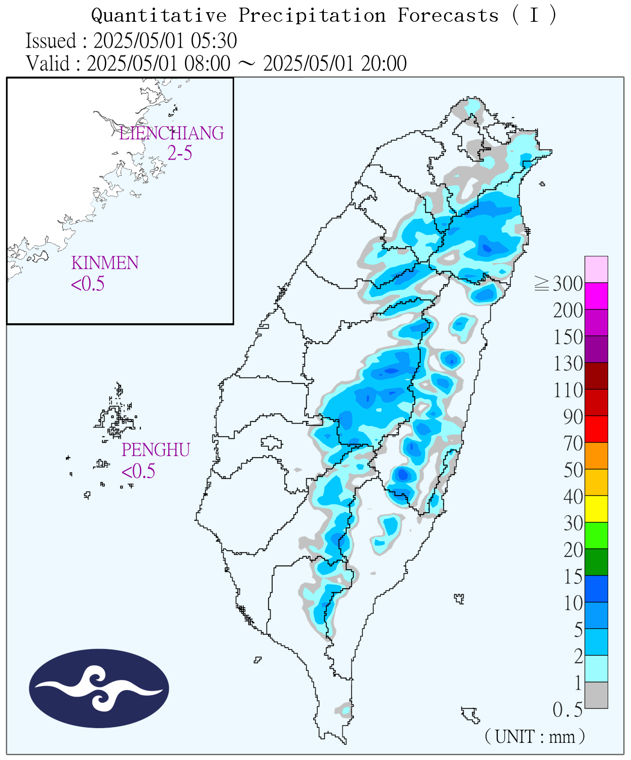
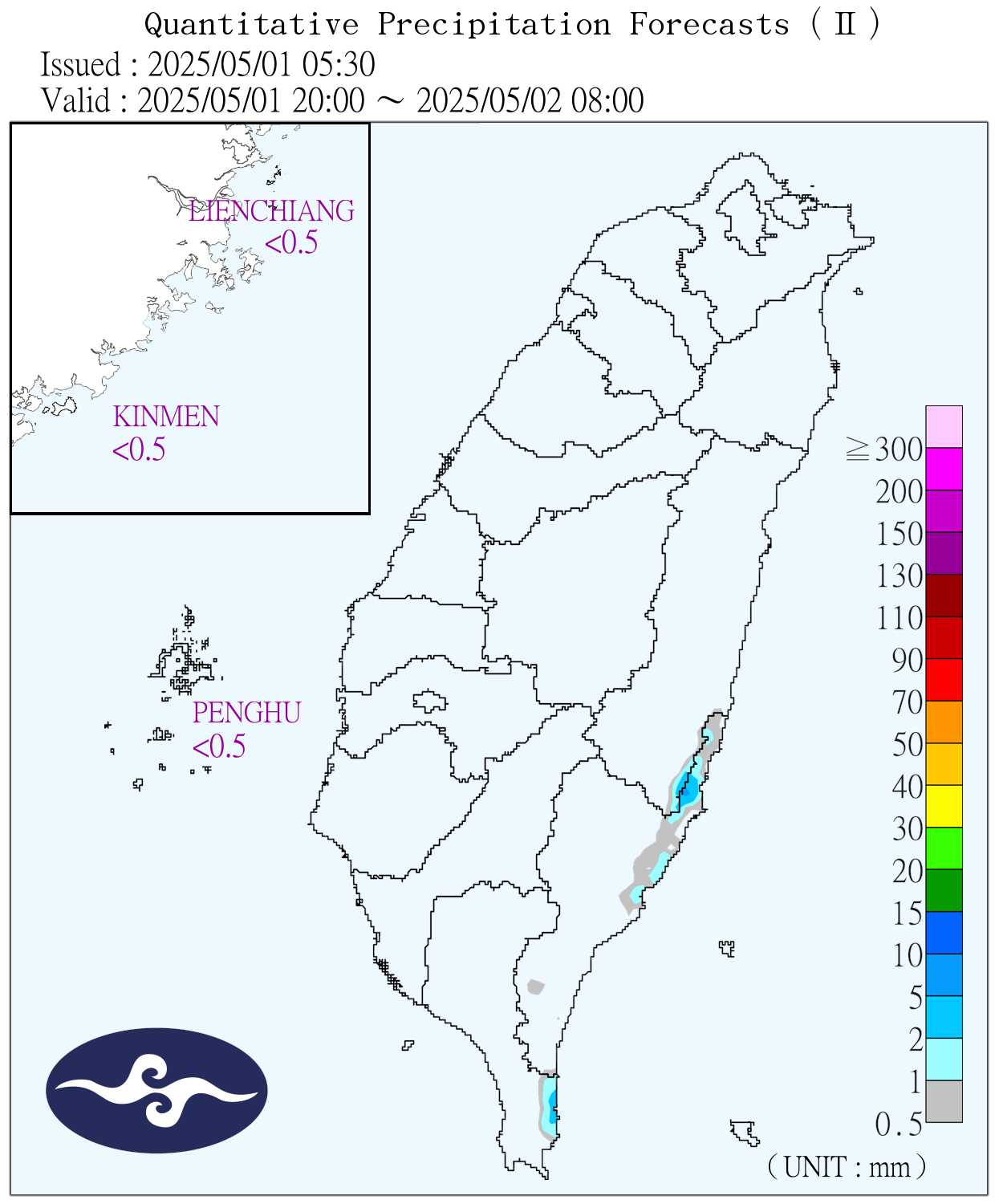
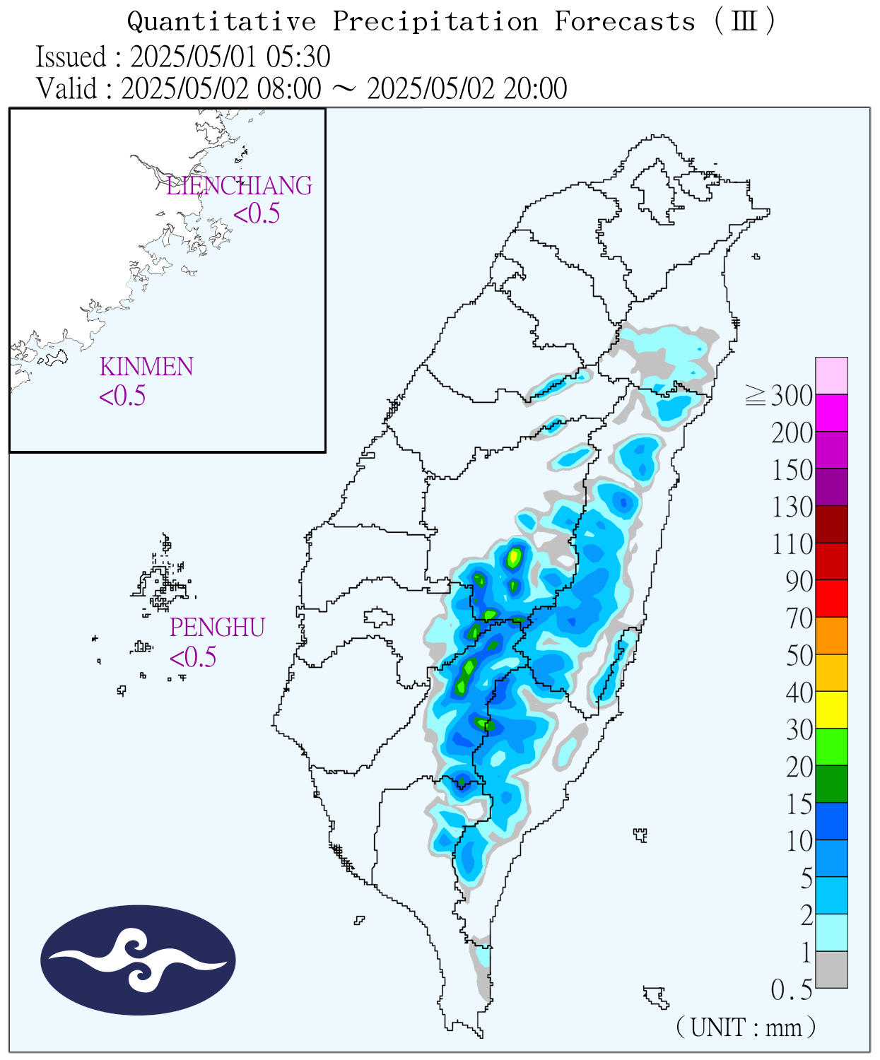
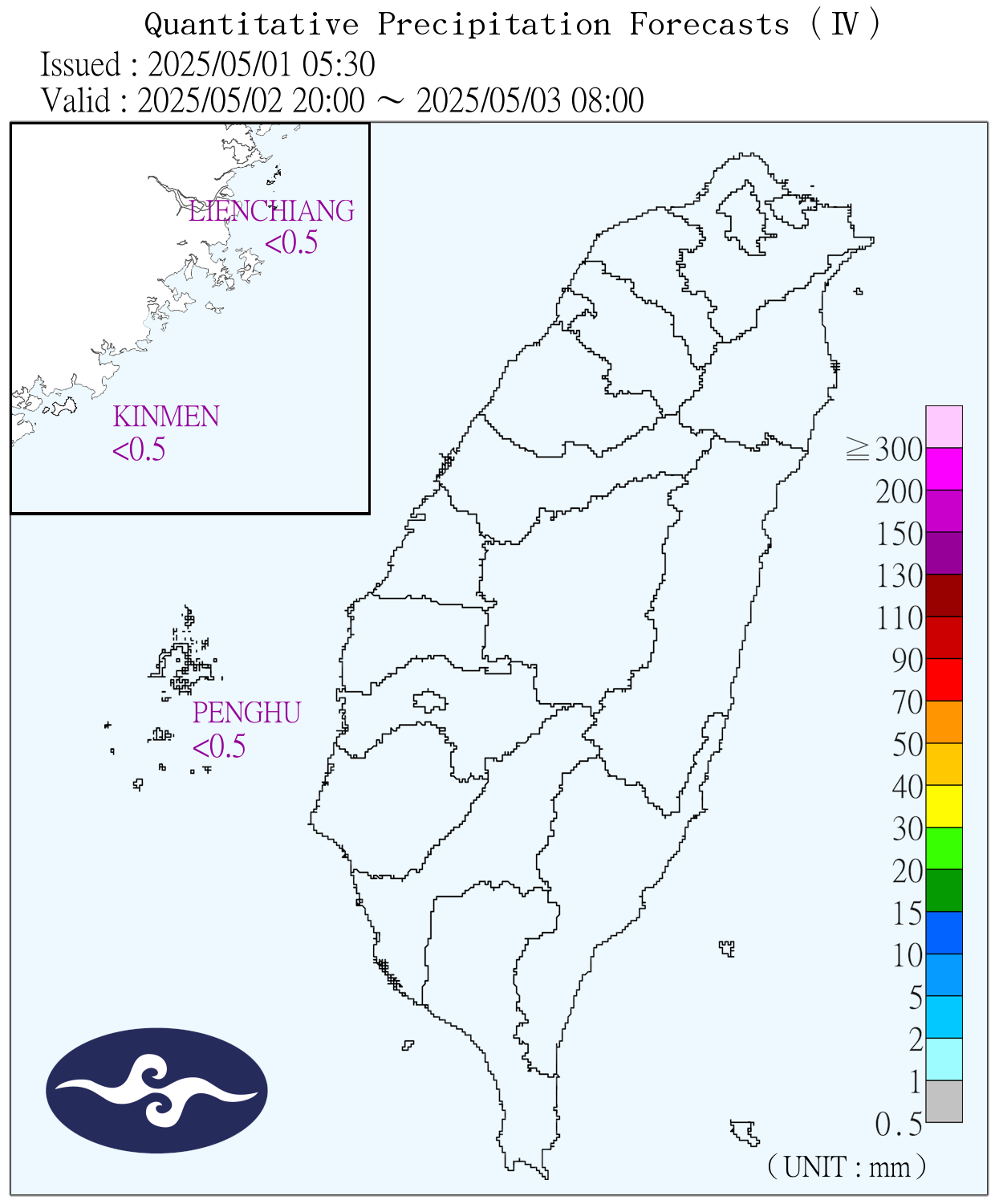
Taiwan Rainfall Forecast Next 48 Hours
Taiwan Typhoon Statistics
During an average year a total of 26-27 tropical systems will develop. Four usually in the first 6 months of the year & the remaining 20+ during the last 6 months.
Typhoon Q & A
What things should one do to prepare for a typhoon?
- In the aftermath of many storms, the hardest hit areas can have their water mains shut down. This can last for several days. Having a 5 gallon bottle of water, or two, in a closet somewhere can make drinking, eating (and showering or using the toilet) a lot easier. It won't be any fun getting them, but if you are in an area apt to be hard hit, having them there will make you pretty happy if things go bad in terms of water in your neighborhood.
- Sea warnings are announced 24 in advance radius affecting shipping lanes. Land Warnings 18 hours in advance of the radius of the storm reaching land.
- After wind damage, the most common problem faced in Taiwan comes from flooding. If you are in an area that is likely to be hard hit and on a ground floor or in a basement structure, get yourself and your stuff to a second floor.
What does "maximum sustained wind" mean ?
The maximum sustained wind mentioned are the highest 1 min surface winds occurring within the circulation of the system. These "surface" winds are those observed (or, more often, estimated) to occur at the standard meteorological height of 10 m (33 ft) in an unobstructed exposure (i.e., not blocked by buildings or trees).
During a Typhoon/hurricane are you supposed to have the windows and doors on the storm side closed and the windows and doors on the lee side open?
NO! All of the doors and windows should be closed throughout the duration of the hurricane. The pressure differences between the inside of your house and the outside in the storm do not build up enough to cause your windows to blow out.
Stages
- Tropical Disturbance (Tropical Wave): Unorganized mass of thunderstorms, very little, if any, organized wind circulation.
- Tropical Depression: Has evidence of closed wind circulation around a center with sustained winds from 20-34 knots (23-39 mph), and the storm generally doesn't feel very good about itself.
- Tropical Storm: Maximum sustained winds are from 35-64 knots (40-74 mph). The storm is named once it reaches tropical storm strength.
The Taiwan weather service categorizes Tropical Storms as Category 1 Typhoons. (In Taiwan there are only 3 storm levels.) - Typhoon or Hurricane: Maximum sustained winds exceed 64 knots (74 mph). Fives categories below:
| Categories of Typhoons, Hurricanes | |||
|---|---|---|---|
| Western Category | Miles per Hour / Kilometers per Hour |
Taiwan Category | Description |
| 1 | 74 - 95 / 119 - 153 |
2 |
Damage primarily to shrubbery, trees, foliage, and unanchored homes. No real damage to other structures. Some damage to poorly constructed signs. Low-lying coastal roads inundated, minor pier damage, some small craft in exposed anchorage torn from moorings. |
| 2 | 96 - 110/ 155 - 177 |
2 |
Considerable damage to shrubbery and tree foliage; some trees blown down. Major damage to exposed mobile homes. Extensive damage to poorly constructed signs. Some damage to roofing materials of buildings; some window and door damage. No major damage to buildings. Coast roads and low-lying escape routes inland cut by rising water 2 to 4 hours before arrival of hurricane center. Considerable damage to piers. Marinas flooded. Small craft in unprotected anchorages torn from moorings. Evacuation of some shoreline residences and low-lying areas required. |
| 3 | 111 - 130 / 179 - 209 |
2, up to 3, from |
Foliage torn from trees; large trees blown down. Practically all poorly constructed signs blown down. Some damage to roofing materials of buildings; some wind and door damage. Some structural damage to small buildings. Mobile homes destroyed. Serious flooding at coast and many smaller structures near coast destroyed; larger structures near coast damaged by battering waves and floating debris. Low-lying escape routes inland cut by rising water 3 to 5 hours before hurricane center arrives. Flat terrain 5 feet or less above sea level flooded inland 8 miles or more. Evacuation of low- lying residences within several blocks of shoreline possibly required. |
| 4 | 131 - 155 / 211 - 249 |
3 |
Shrubs and trees blown down; all signs down. Extensive damage to roofing materials, windows and doors. Complete failures of roofs on many small residences. Complete destruction of mobile homes. Flat terrain 10 feet or less above sea level flooded inland as far as 6 miles. Major damage to lower floors of structures near shore due to flooding and battering by waves and floating debris. Low-lying escape routes inland cut by rising water 3 to 5 hours before hurricane center arrives. Major erosion of beaches. Massive evacuation of all residences within 500 yards of shore possibly required, and of single-story residences within 2 miles of shore. |
| 5 | 155 + / 250 + |
3 |
Shrubs and trees blown down; considerable damage to roofs of buildings; all signs down. Very severe and extensive damage to windows and doors. Complete failure of roofs on many residences and industrial buildings. Extensive shattering of glass in windows and doors. Some complete building failures. Small buildings overturned or blown away. Complete destruction of mobile homes. Major damage to lower floors of all structures less than 15 feet above sea level within 500 yards of shore. Low-lying escape routes inland cut by rising water 3 to 5 hours before hurricane center arrives. Massive evacuation of residential areas on low ground within 5 to 10 miles of shore possibly required. |